Best Denver Neighborhoods for RTD Light Rail Access
Buying a home near Denver light rail or BRT? Here's how the top transit-connected neighborhoods compare on access, walkability, and home prices.
Denver gets labeled a car city, and for most of the metro, that's fair. But a growing number of buyers — especially relocators and remote workers — are actively filtering for neighborhoods where RTD light-rail or BRT makes car-optional living genuinely possible. That's a real purchase decision with real stakes: choosing the wrong neighborhood for your commute pattern can cost you time and money every week for years.
The good news is that Denver's inner-ring neighborhoods vary dramatically on transit access — and the differences are measurable. Some neighborhoods put you steps from a light-rail platform with a Transit Score in the 60s or 70s. Others are technically "near" a station but require a car to reach it. A few, like Wash Park, score beautifully on other dimensions but will disappoint you if transit is the priority.
This guide groups Denver's most transit-accessible neighborhoods by which RTD corridor serves them — the central and downtown-adjacent lines, the Southeast Corridor (H Line), and the West Corridor (W Line) and northwest Denver. For each neighborhood you'll find walkability scores, transit scores, and an honest read on the trade-offs. Our Denver neighborhood overview covers the full metro picture if you want broader context.
Light Rail Corridors: Central and Downtown-Adjacent Neighborhoods
These are the neighborhoods where car-free living is most achievable in Denver — all within a short walk of a downtown light-rail station on the Central Corridor or connecting lines, with Walk Scores in the 90s and Transit Scores that back up the claim.
Five Points
Five Points sits just northeast of downtown and is one of the most transit-connected neighborhoods in the city. You can run almost every errand on foot, and solid RTD access via the Central Corridor light-rail stations at 30th & Downing and 25th & Welton means downtown is always a short ride away. The Bike Score of 98 (Biker's Paradise) makes it one of the strongest multi-modal neighborhoods in Denver.
- Why transit buyers love it: Walk Score 94, Transit Score 55, Bike Score 98; Central Corridor light light-rail at 30th & Downing and 25th & Welton; downtown, Union Station, and Coors Field reachable on foot or by light-rail
- Typical prices: Neighborhood-level pricing is actively shifting — check current listings for the most accurate read; the Denver MSA median sits at $574,900 across all property types
- The trade-off: Five Points delivers the strongest multi-modal profile in this group, but it's a denser, more urban environment than the quieter residential streets further south. A yard and a quieter block cost you this level of access.
RiNo
RiNo (River North Art District) sits just north of Five Points along the South Platte River. It's a step down from Five Points on walkability, but the 38th & Blake station connects you directly to Denver International Airport on the A Line — a differentiator that matters if you travel frequently. The Bike Score of 97 (Biker's Paradise) is exceptional.
- Why transit buyers love it: Walk Score 76, Transit Score 54, Bike Score 97; 38th & Blake station on the A Line gives direct airport access; strong bike infrastructure along the Platte River trail
- Typical prices: Active market with a mix of condos, townhomes, and lofts; check current listings for neighborhood-level pricing
- The trade-off: RiNo's transit access is real but slightly more limited than Five Points on pure light light-rail frequency. The A Line connection is a genuine differentiator if you travel frequently or commute to DIA. The neighborhood is louder and more industrial in character — that's the trade for the energy and the access.
Uptown
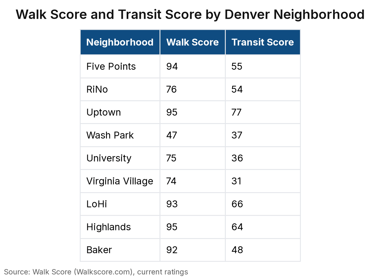
Uptown is just a few blocks northeast of downtown and delivers the highest Transit Score in this entire guide — the only neighborhood here that earns an Excellent Transit designation. Multiple BRT and bus rapid transit routes run through it, and downtown light-rail stations are a short walk away. The chart below shows how it stacks up against every other neighborhood on both walk and transit scores.
- Why transit buyers love it: Walk Score 95, Transit Score 77 (Excellent Transit — highest in this guide), Bike Score 97; multiple BRT and bus routes along Colfax; downtown light light-rail within walking distance; restaurants and hospitals reachable on foot
- Typical prices: Uptown skews toward condos and smaller multi-family buildings; check current listings for neighborhood-level pricing
- The trade-off: Uptown is dense and urban — that's what buys you the Transit Score of 77. Single-family homes with a yard are limited here, and green space is scarcer than in the neighborhoods further south.
Southeast Corridor (H Line): Established Neighborhoods Along the I-25 Spine
These neighborhoods sit within a reasonable distance of the H Line (Southeast Corridor) or the Evans and University light-rail stations. They're not the highest Transit Scores in the city, but they're meaningfully better than the suburban fringe — and they come with quieter streets, larger lots, and more established residential character than the downtown-adjacent tier.
Wash Park
Wash Park is built around Washington Park, one of Denver's largest green spaces, and it's appealing on almost every dimension except transit. Its walk and transit scores are the lowest in this entire guide by a wide margin — the chart makes that gap hard to miss. If transit access is a priority, be honest with yourself about that before you fall in love with the park.
- Why transit buyers love it: Bike Score 81 (Very Bikeable); the Platte River trail and park paths make cycling a real option; the Evans light light-rail station on the H Line is reachable by bike
- Typical prices: Wash Park commands a premium for its park access and lot sizes; check current listings for neighborhood-level pricing
- The trade-off: This is the clearest example in Denver of a neighborhood where lifestyle attributes and transit access point in opposite directions. The park, the mature trees, the larger lots — those are real. The transit score is also real, and it's low. If you're planning to commute by light-rail, budget for the bike ride or the drive to the Evans station.
University
University sits south of downtown along the I-25 spine, adjacent to the University of Denver campus and the Evans light light-rail station on the H Line. It's more walkable than Wash Park but still requires intentionality about transit use — the Evans station is right there, but the transit score tells you this isn't a ditch-the-car-entirely neighborhood. The Bike Score of 86 (Very Bikeable) is strong.
- Why transit buyers love it: Walk Score 75, Transit Score 36, Bike Score 86; Evans station on the H Line is within the neighborhood; the H Line connects south to the Tech Center and north to downtown and Union Station
- Typical prices: University offers a mix of single-family homes and smaller multi-family; check current listings for neighborhood-level pricing
- The trade-off: The Evans station is the anchor here, and it's a real asset for anyone commuting to the Tech Center or downtown. But the transit score tells you that transit works for those specific trips — it's not a neighborhood where you'll ditch the car entirely. If your commute aligns with the H Line, this is a strong option.
Virginia Village
Virginia Village is a quieter, more residential neighborhood southeast of downtown, sitting between the H Line corridor and the Cherry Creek area. It's solid for walking, but it has the lowest Transit Score in this guide. The Bike Score is decent — the chart below has the full breakdown.
- Why transit buyers love it: Walk Score 74, Bike Score 76; proximity to the H Line corridor via bike or short drive; quieter streets and larger lots than the neighborhoods closer to downtown
- Typical prices: Virginia Village tends to be more affordable than Wash Park and University; check current listings for neighborhood-level pricing
- The trade-off: The transit score is honest — this neighborhood has some transit, but it's not a transit-first neighborhood. If you're buying here for light light-rail access, map the specific walk or bike route to your nearest station before you commit. The neighborhood's strengths are its residential character and relative value.
West Corridor (W Line) and LoHi: Northwest Denver's Transit-Accessible Pockets
Northwest Denver's most walkable neighborhoods cluster around the W Line and the 16th Street Mall BRT connection. LoHi and Highlands deliver the strongest Walk Scores in this corridor, and Baker earns its place here via the W Line's Perry and Knox stations — specific enough that you can pull up the walk time yourself before you make an offer.
LoHi
LoHi (Lower Highlands) sits just across the South Platte River from downtown. You can reach downtown light-rail stations on foot or by the free MallRide, and nearly every errand is walkable. Strong BRT and bus coverage round out the access — the chart below shows how it compares to the other north-side neighborhoods. The Bike Score of 87 (Very Bikeable) rounds out a strong multi-modal profile.
- Why transit buyers love it: Walk Score 93, Transit Score 66 (Good Transit), Bike Score 87; 16th Street Mall BRT and MallRide connect to downtown light light-rail; downtown restaurants, Union Station, and Coors Field reachable without a car
- Typical prices: LoHi commands a premium for its walkability and restaurant scene; check current listings for neighborhood-level pricing
- The trade-off: LoHi's transit access is strong for downtown-oriented commutes, but the W Line itself isn't the primary connection here — it's the BRT and bus network. If your commute goes west on the W Line, verify the specific connection. The price premium is real; you're paying for the walkability and the dining scene.
Highlands
Highlands sits just north of LoHi along the northwest side of Denver, and its Walk Score ties Uptown for the top spot in this guide. BRT and bus routes connect you to downtown, and the Bike Score is strong. The dining and bar scene along 32nd Avenue and Tennyson Street is what most buyers come here for first.
- Why transit buyers love it: Walk Score 95 (tied for highest in this guide), Transit Score 64 (Good Transit), Bike Score 89; 16th Street Mall BRT connection via LoHi; nearly every errand on foot along 32nd and Tennyson
- Typical prices: Highlands is a premium market; check current listings for neighborhood-level pricing
- The trade-off: Highlands and LoHi are the clear leaders among the north-side options on walkability. The transit score is good but not exceptional — the neighborhood works best for buyers whose primary commute is downtown-oriented. Parking can be tight near the commercial strips, which makes the walkability more valuable than it might look on paper.
Baker
Baker sits south of downtown along the W Line corridor, served by the Perry and Knox stations — both within the neighborhood, running west to Lakewood and connecting to downtown via the Auraria campus. It's excellent for walking, but transit is a step down from LoHi and Highlands. The Bike Score of 97 (Biker's Paradise) is exceptional.
- Why transit buyers love it: Walk Score 92, Bike Score 97 (Biker's Paradise); Perry and Knox stations on the W Line within the neighborhood; W Line connects west to Lakewood and east to downtown
- Typical prices: Baker tends to be more accessible than LoHi and Highlands; check current listings for neighborhood-level pricing
- The trade-off: Baker's transit score is honest — the W Line is real and the stations are walkable, but frequency and coverage aren't at the level of the downtown-adjacent neighborhoods. If your commute goes west on the W Line, Baker is genuinely well-positioned. The Bike Score of 97 makes cycling a strong alternative for short trips.
So Which Neighborhood Actually Wins on Transit?
The honest answer: Uptown wins on Transit Score, and it's not particularly close — it's the only neighborhood here that earns an Excellent Transit designation. Five Points and LoHi follow, with Highlands and RiNo close behind. If you're optimizing purely for transit access, the downtown-adjacent neighborhoods are where the scores cluster highest.
But "most transit" and "best fit" are different questions, and the gap between them is where most buyers make mistakes. Here's what actually decides it:
How often you'll use transit vs. drive. If you're commuting downtown five days a week by light-rail, Uptown or Five Points give you the strongest daily-use case. If transit is a nice-to-have for occasional trips, the difference between a Transit Score of 66 and 48 matters a lot less.
Whether you need airport access. RiNo's 38th & Blake station on the A Line is the only neighborhood in this guide with a direct light light-rail connection to Denver International Airport — a differentiator that doesn't show up in the Transit Score alone.
Whether you're commuting downtown or to the Tech Center. The H Line serves University and connects south to the Tech Center — a completely different commute pattern than the downtown-oriented BRT connections that serve LoHi, Highlands, and Five Points. University's transit score understates its value if the H Line is your line.
What price point you're working with. The neighborhoods with the highest Transit Scores — Uptown, Five Points, LoHi, Highlands — also tend to command price premiums. Baker and Virginia Village offer more accessible entry points with real, if lower, transit access.
The Transit Score spread across these nine neighborhoods represents genuinely different daily experiences — Virginia Village at the low end, Uptown at the top, with a 46-point gap between them. Don't let a map filter substitute for walking the actual route from a specific address to the platform you'd use. The most walkable neighborhoods in Denver is a good companion read if you want to dig deeper on the walkability side.
Thinking About Buying Near Denver Light Rail?
A Zillow filter for "near transit" can't tell you which neighborhoods are actually walkable to the platform versus technically close to a station but requiring a car to reach it. The difference between a 5-minute walk and a 15-minute walk to a platform is the difference between using transit daily and using it occasionally — and that gap doesn't show up in a map pin.
What I can do is match you to a shortlist of neighborhoods based on your actual commute destination, price band, and what you're willing to trade. If you're commuting to the Tech Center, the H Line neighborhoods look different than if you're going downtown. If you need airport access, RiNo's A Line connection changes the calculus. If walkability matters as much as transit, Uptown and Highlands pull ahead of Baker and Virginia Village.
Bring your commute destination, your budget, and your must-haves. I'll bring neighborhood-level transit knowledge and recent comps. Book a consultation and let's figure out which neighborhood actually fits how you'll live.
---
Paul McCoy, Realtor | Fathom Realty | License #: FA.100105533 | (319) 325-0668 | pmccoy626@gmail.com
Paul McCoy is a licensed real estate professional in Colorado. Equal Housing Opportunity.